![[Link to www.VanGoghGallery.com]](/images/logoh.jpg) |
A McGough—McMahon Connection? |
| |
A McGough—McMahon Connection? |
The McGoughs may have been a sept of the McMahons of the territory of Mughdhorna
in Airghialla. Peadar Livingstone suggests such
a connection in The Monaghan Story (page 70). See the discussion under
Which Eochaidh—A MacMahon Connection?
in Origins of the Surname McGough. The Mhigh Eothachs
or Mag Eochys, who gave their name to Ballymageogh and Slievemageogh
in county Down, migrated from county Monaghan to county Down between 1150 and
1200. This move was from Mughdhorna, a territory over which the McMahons were
establishing control. The move is described in the MacMahon genealogies where
the Mag Eochys are sometimes called a sept of the MacMahons, and are sometimes
referred to as a separate family. See my web pages Where
the Mountains of Mourne Sweep Down to the Sea— Ballymageogh and Slievemageogh
in County Down and Mughdhorna.
Because of the possibility of a connection between the McMahons and McGoughs, I have collected on this page information on the McMahons in Airghialla. For much more on this subject, see: Introduction to the Genealogy from the Collas to the MacMahons.
| |
|
| |
Beginning in 1300 A.D. and continuing through 1600, Ireland's History in Maps designates what is now county Monaghan as MacMahon Country. The ascension of the MacMahons to power in Monaghan began in the late 1100s.
In Landscapes of South Ulster: A Parish Atlas of the Diocese of Clogher, by Patrick J. Duffy (The Institute of Irish Studies of the Queen's University of Belfast 1993), the author tells us:
"The MacMahons originated around Leck in Kilmore Parish and established their base in the Monaghan area by the 14th century. In the following two centuries, the MacMahons of Farney, Dartrey and Monaghan competed successively with each other for the lordship of Airghialla. ... The MacMahons emerged as the dominant force in Airghialla in the 13th century and by the 16th century they had gradually filtered down to take over occupation of most of the ballybetaghs and tates in Monaghan County." (pages 11 and 12) For more, see Mughdhorna in this website.
A website with a good history of the McMahons is: Clan McMahon of the Kingdom of Oriel—Counties Monaghan, Armagh, Fermanagh, Louth and Derry Ireland and Beyond.
According to Peadar Livingstone, the Mac Mahons were part of the Ua Nadsluaig whose original power base was at Lough Ooney. The Monaghan Story, page 39.
"Lough Ooney [was] undoubtedly the most important centre in the story of early Christian settlement in west Monaghan. On the eastern shore of this lake are the crannógs which formed the centre of the ancient ríocht or kingdom of Dartraighe-Coninse, from which the later barony of Dartrey, including the district of Connons, takes its name. From here the Boylans and OCarrolls and other dynasties ruled the surrounding countryside until eventually displaced by the intrusion of the Normans into the area and the rise of the MacMahons." Border Dander, Tour 2 A, on The Clones Home Page.
There is a chart of the Clan Nadsluaig that shows the relationship of the O'Carrolls and McMahons on the website: The Clan McMahon of the Kingdom of Oriel. Go to The MacMahon Story and click on The MacMahon Lineage. See especially the page entitled Introduction to the Genealogy from the Collas to the MacMahons and the nine attached lineage charts prepared by Donald Schlegel.
O'Donovan's notes to the year 849 in the Annals of the Four Masters describe Lough Ooney as follows:
"Loch Uaithne: i.e. Uaithne's Lough, now Lough Ooney, situated near the village of Smithborough, in the barony of Dartry and County of Monaghan. The chief of Dartraighe-Coininse had his principal residence at this lake, and hence was sometimes called lord of Loch-Uaithne."
Two entries in the Annals of the Four Masters for 849 are:
M849.12 Caireall, son of Ruadhrach, lord of Loch Uaithne, was slain by the Conaille.
M849.13 Eochaidh, son of Cearnach, lord of Feara Rois, was slain by the foreigners.
The area around Lough Ooney was originally called Fernmag or Fer Fernmaighe (Farney), which should not be confused with Fear Manach (Fermanagh). The Monaghan Story by Peadar Livingstone, page 19. When the Ua Nadsluaig (McMahons, and later O'Carrolls) moved eastward from Lough Ooney, the took the name "Farney" with them:
"While still at Lough Ooney, the Ua Nadsluaig has been known as the Fir Fernmaige and their kings as kings of Fernmaig, or Farney. When they migrated, they brought this name with them and eventually gave it to part of the area where they settled. As a result, the barony of Farney is today in south Monaghan, many kilometers from where the name began." (Livingstone, page 41).
The townland of Loughoony, in which Lough Ooney (or Oony) is located, is in the south-central part of the modern Catholic parish of Roslea, about three kilometers southwest of the small town of Smithborough. It lies immediately to the north of highway N54, which runs from Monaghan southwest to Clones; 12 kilometers southwest of Monaghan; and 7 kilometers northeast of Clones. It is at H560 298 in the Irish grid system on sheet 27 (Upper Lough Erne) of the 1:50,000 maps of the Ordnance Survey of Northern Ireland, and on sheet 28A (Cavan, Fermanagh, Monaghan, Tyrone) of the Discovery Series of the Ordnance Survey of Ireland. The latter map shows a crannog in the lake.
In his Landscapes of South Ulster: A Parish Atlas of the Diocese of Clogher, Patrick J. Duffy comments:
"By the 10th century Clones monastery and territory around it occupied by the Fer Fernmaighe had emerged as one of the dominant regions in Airghialla, and Loch Uaithne (Loughoony) is mentioned as the headquarters of this medieval kingdom." (page 64).
Livingstone says:
"The County's most celebrated crannog [man-made island] was at Lough Ooney, near Smithborough. This particular crannog seems to have been the headquarters of the Fir Fernmaige for many centuries. It is mentioned in the Annals of Ulster as early as 719." (page 35).
The Annals of Ulster report that in 1025 the Fermanach attacked the Ua Nadsluaig on the brink of Loch n-Uaithne [Lough Ooney], where they burned buildings and killed seventeen men on the brink of the loch.
"U1025.5 "Cathalan, king of Fernmag, made a raid on Fir Manach. The Fir Manach forthwith made a raid to Loch Uaithne, and burned [the district] and killed seventeen men on the shore of the lake."
"U1025.5 Crech la Cathalan, ri Fernmuighi for Feraibh Manach. Crech la Firu Manach focetoir co Loch n-Uaithne coro loiscset & coro marbsat .uii. firu dec for bru ind locha.
Livingstone says:
"It may have been this incident which finally persuaded Ui Nadsluaig to look eastwards. This would bring them into immediate conflict with the Mugdorna, Ui Meith, Fir Rois, and Conailli. As it happened, all of these kingdoms were doomed to disappear very quickly." (Page 39).
The O'Carrolls, kings of Farney, were of the Ui Nadsluaig who moved eastwards from Lough Ooney. The most powerful of the O'Carroll kings of Farney was Donnchadh, who ruled from 1125 until his death in 1168. He was succeeded by his son, Murchadh. Livingstone notes that Murchadh was an active and effective ruler, but his coming to power coincided with the arrival in Ireland of the Anglo-Normans. In 1171, Murchadh made his submission to king Henry II of England. He nonetheless fought the Normans and troops of John de Courcy in 1176 and 1177, but afterwards allied with Hugh de Lacy and his Normans. Murchadh O'Carroll died in 1189, still the nominal king of Airghialla, although the Normans had occupied the part of Meath that his father had controlled.
Prior to the death of king Murchadh O'Carroll, land around Dundalk had been granted to the Norman, Gilbert Pipard, and land around Ardee had been granted to Bertram de Verdon, including the "half cantred of Mudorne." On Murchadh's death, Pippard and de Verdon set out to occupy the land. One of their first victims was Muircheartach O'Carroll, the last O'Carroll king of Airghialla, whom they captured in 1193, put out his eyes, and hanged.
Livingstone points out that not all the Ui Nadsluaig moved east with the O'Carrolls, and the MacMahon family sprang from those that remained at Lough Ooney.
The History of Our Towns & Villages by Ciara Nolan, on Local Ireland's Monaghan web page, tells us:
"Monaghan is the capital town in the county, hence giving its name to the county. It was the centre point of the MacMahon power who ruled over much of the county from the latter end of the 11th century. The MacMahons always held forts in the area and in the 14th century moved their headquarters from Lough Leck to a crannog on an island on what is now known as The Convent Lake."
The Convent Lake is immediately south of the town of Monaghan (and is not to be confused with Peter's Lake immediately north of the Diamond). The article by Ciara Nolan tells us:
"St. Louis Convent is by a little lake and has an attractive chapel, it’s an excellent example of 19th century convent architecture. The lake it self once being home to the MacMahon family."
In 1995, Theo McMahon published Old Monaghan 1785–1995, a book of photographs and reminiscences. On page 10 is a map of Monaghan in 1787. (The same map is published at page 74 of Patrick J. Duffy's Landscapes of South Ulster.) What is now known as Convent Lake is shown on the map, around a mile southwest of the Diamond, as Spark's Lake. What later was to become St. Louis Convent was shown as a malt house or brewery in 1787. The map shows a crannog in the center of the lake. There is a photograph taken in 1906 of the convent and the lake, at page 57, and a picture of one of the nuns feeding scraps to a swan on the lake at page 207.
But where is Lough Leck, headquarters of the MacMahons before the move in the 14th century to Convent Lake south of the town of Monaghan? Evelyn Philip Shirley, at page 71 of The History of County Monaghan, says:
"The inauguration stone of the MacMahons no longer exists on the hill of Leck, formerly called Mullagh Leaght, or The Hill of the Stone, three miles S.W. of Monaghan, in the parish of Kilmore ; it is marked on an ancient MS map of Ulster in the State Paper Office, 'Mullagh lost, so called of a stone there of which McMahon is made.' The impression of the foot was effaced by the owner of the farm about the year 1809, and about the year 1856 it was wantonly destroyed, and broken into flags, and used in the construction of a stable." (Livingstone, at page 46 of The Monaghan Story, says that in 1846 the stone was removed by a man named Bephel and used to build a barn.)
Shirley adds this footnote to his text:
"The stone measured six feet five inches long, by four feet four inches broad ... Thirty years ago there was a tradition that the golden chair of the Kings of Ireland lay beneath this flag, which actually led to some attempts to raise it."
Shirley lists the townlands of the Parish of Kilmore at pages 457–461 of his book. He lists both the townlands of Leck and Ballyleck. He says Leck means "Hill-side," and was allotted to Brian McCabe McDonnell in 1591. He says: "Here was the famous McMahon stone." In 1879, the proprietor of Leck was Henry Jackson, Esquire. I did not find a listing for Leck in the census of County Monaghan for 1659, but their were twelve people, all Irish, residing in the adjoining townland of Ballagh. (Shirley, page 552).
Shirley says Ballyleck means "Town of the Flag Stone." He says Ballyleck was the seat of John Burnett, Esquire, who died on December 11, 1632. See "Burnett of Ballyleck" at pages 211–216 of The History of County Monaghan. Shirley says Burnett was the owner of a vast estate in several baronies of county Monaghan that Burnett had purchased from the old proprietors. Ballyleck afterwards belonged to the Montgomerys and, at the time of publication of Shirley's book in 1879, to Lieutenant Colonel (Jesse—of the Monaghan Militia) Lloyd. See The Lloyd papers (D/3406/F) in The Martin & Brett Archive (D/ 3406) of PRONI. The census of county Monaghan in 1659 shows four people living in Ballyleck, 3 English and one Irish. (Shirley, page 552)
The high spot on the hill in the townland of Leck in Kilmore and Drumsnat parish is between 3.1 and 3.2 statute miles (5.1 kilometers) southwest of the Diamond in the town of Monaghan, and is almost certainly the hill on which the McMahon stone was located.
Patrick J. Duffy, in Landscapes of South Ulster, at page 76, says that the "ballybetagh of Ballilecke ... contained the Hill of Leck (Mullach Leachta) where the McMahon lords were inaugurated throughout the middle ages ... " Duffy says: "There was a crannog on Lough Leck which was probably the headquarters of the MacMahons, who originated in this district in the 11th century." (page 26). Livingstone says that Loughleck, near Corcaghan, was the original headquarters of the McMahon dynasty. (page 35). I find no lake in the area that is marked Lough Leck on modern maps.
I originally mistakenly assumed the "ballybetagh of Ballilecke," which Duffy says contains the hill of Leck, was the townland of Ballyleck on the eastern boundary of the parish of Kilmore—on the western boundary of the parish of Monaghan. The townland of Ballyleck is about 3 kilometers west by southwest of the town of Monaghan, just south of N54, and is on the abandoned Ulster Canal that was carved through the townland in 1842. The nearby White Bridge, I assume, crosses a remnant of the canal. In the townland of Ballyleck, at map coordinates H644 321, a kilometer southeast of White Bridge, is a tiny lake, identified on sheet 28A of the Discovery Series of maps as Ballyleck Lake. The lake is not named on sheet 28 map the Ordnance Survey of North Ireland. The Ordnance Survey Memoirs of Ireland, Counties of South Ulster 1834–8 (Volume 40, published by The Institute of Irish Studies, The Queen's University of Belfast), at page 159, says:
"Ballyleck lake occupies a portion of the township of Camla in this parish [Monaghan] and a portion of Ballyleck townland in the adjacent parish of Kilmore. It is 243 feet above the level of the sea, 3 acres 2 roods in content and averages 10 feet in depth."
This is a description of the Ballyleck Lake shown on the modern sheet 28A map. The map shows no crannog in the lake and, indeed, the lake seems to be too small to offer much protection to a crannog. There is a small hill to the southwest of the lake. I am now convinced that this lake and hill are not the correct site of the McMahon stone, but the research that had led me to this conclusion is worth setting out here.
Earlier, I had speculated that Lough Leck might be the lake, unnamed on the Northern Ireland ordnance survey maps, but named on the newer sheet 28A, called Priestfield Lake within the Rossmore Forest Park, on the grounds of the demolished Rossmore Castle. This lake is on the boundary between the townland of Corlatton in the parish of Monaghan and the townland of Cornaglore in the parish of Kilmore, and lies in Corlatton. The Northern Ireland map shows what looks like a small island near its northwestern end, but the newer sheet 28A shows neither an island nor a crannog. There are four other smaller lakes within the Rossmore Forest Park which might be considered. For a little of the history of Rossmore Park, see The Rossmore Papers on the web sit of the Public Records Office of Northern Ireland. This speculation was also wrong.
One fact led me to give the townland of Ballyleck more consideration than I should have. Livingstone says at page 47 of The Monaghan Story:
"Although the inauguration ceremony continued to take place on the hill of Leck, the MacMahon headquarters moved firstly to Tullybryan and, sometime after 1365, to the modern town of Monaghan. Here the stronghold was at the crannog of Rath Tully on the Convent Lake."
Shirley, at page 199, notes that:
"[A]bout the middle of the fourteenth century we find the chief Brian, son of Hugh Mac Mahon, expelled from fortress of Rath-Tulad, now called Tully, a townland adjoining [to the south] the townland of Monaghan. This Brian, called The Great Mac Mahon, was treacherously murdered by one of his own people, in the year 1372."
Elsewhere, Livingstone describes "Tullybryan, near Ballinode" (Bellanode on the modern maps?) as a "stronghold of the MacMahons" (page 35) . He implies that there was a ringfort there. Tullybryan is the townland that adjoins the townland of Ballyleck to the north.
Livingstone's description of "Loughleck" as "near Corcaghan" some supports the correct location of the hill of Leck to the south of the townland of Ballyleck, perhaps in the townland of Leck. The townland of Corcaghan is 5 to 6 kilometers south of the townland of Ballyleck and contains a small lake called on modern maps Corcaghan Lough (called Corcoghan Lough on Northern-Ireland sheet 28). The townland of Leck is less than 2 kilometers to the north. Ann McGeough Harney lists a St. Michael's Church in Corcaghan (under Kilmore & Drumsnat), the construction of which began in 1806. Ballagh Lough is about 1 3/4 kilometers north by northeast of Corcoghan Lough, about 2/3rds of the distance to Ballyleck Lough.
Jeff McMahon, a former newspaper columnist who freelances in Chicago and teaches writing at the University of Chicago, says in an email of June 29, 2002, that Lough Leck is the lake that is now called Ballagh Lough, about two kilometers south by southeast of Priestfield Lake:
"I'm just back from County Monaghan, where I searched extensively for Lough Leck, the old coronation site of the McMahon kings. Like you, I had assumed it was at Ballyleck, but the smart folks at the Clogher Historical Society assured me it is actually two miles further south in the townland of Leck, which is much closer to Corcaghan. Both Duffy and Livingstone place the lake in this location. The lake in question appears on modern maps as 'Ballagh Lough.' It has a crannog site and sits beside the hill of Leck. I paid a visit to the spot."
Ballagh Lough is at the western tip of the townland of Leck, where Leck adjoins the townland of Ballagh to the south. The map coordinates are H643 288. The lake is 8 kilometers (5 miles) west and one kilometer south of Lough Ooney. Map 28A shows a crannog in Ballagh Lock. One kilometer to the east of Ballagh Lough, in the townland of Leck, is the high spot of a hill that rises to 172 meters. There are no higher hills to the immediate north, but other hills to the south and west are higher. A few exceed 200 meters.
Jeff McMahon's conclusion as to the location of the hill of Leck is consistent with that of Patrick J. Duffy. In his Landscapes of South Ulster, at page 118, Duffy lists the site of McMahon's stone as in the townland of Leck.
Lough Leck and Ballyleck Lake are two different lakes. The townland of Camla, where the Ordnance Survey places Ballyleck Lake, is around three kilometers to the north of Ballagh Lough. A hill that is about a kilometer southwest of Ballyleck Lake rises to a mere 98 meters, and neither this nor any other hill in the immediate area of Ballyleck rises to the stature of a mountain. On the basis of Jeff McMahon's information and the conclusion of Father Livingstone, who was born and raised in county Monaghan, Ballagh Lough is the more likely location of the former Lough Leck.
A map entitled "A Generalle Description of Ulster," a map of Ulster in 1602–03, will be found at page 49 of Historical Maps of Ireland by Michael Swift (Chartwell Books 1999). All the maps in the book are from a collection of the Public Record Office at Kew in west London. On the map, Mullagh Leck, or the hill of Leck (Mullach Leachta), is shown to the west by southwest of the Diamond in the town of Monaghan. Below Mullagh Leck is the word "Uriel" and below that "M. Maghon." To the west of Mullagh Leck, with a slight southerly component, is "Lough Rooskie." (Roosky Lough is H570 267 on sheet 28A.) To the southeast of Mullagh Leck on the old map is "Lough Cornaglare" (H650 301 on sheet 28A). In fact, on modern maps, Lough Cornaglare is one and a half kilometers north of the hill of Leck. Further south by southeast on the old map is Lough Baugh, which is on the upper northwest edge of the area marked "Owenagh." The last two names are in script that is difficult to read, and the names inscribed could be otherwise interpreted. I had to make enlargements of the map and examine them with a magnifying glass before I reached my conclusions. Further, the notation is difficult to read and may not say "Lough Baugh" at all. The famous Irish historian, Dr. John O'Donovan, drew a sketch copying part of this map. The sketch was found among his papers for Armagh and Monaghan at the Armagh City Reference Library. The sketch is published as "Appendix 7 'The Owenagh'" at page 34 of At the Ford of the Birches: The History of Ballybay, It's People and Vicinity, by James H. Murnane and Peadar Murnane. O'Donovan copied the phrase in question as "Bellagh-begh."The cartographer seems to have entered landmarks in this area of the old map because of their importance to the history of the McMahons, rather than on the basis of their geographical recognizability. Ballagh Lough, as shown on this map, is a long distance south of Mullagh Leck, and is in an area where I would place the modern town of Ballybay (Béal Atha Beithe). The compass directions and distances in this area of the old map are unreliable, but the map, as I interpret it, supports an argument that Ballagh Lough was placed by the map maker several miles southeast of the hill of Leck.
So what was the "ballybetagh of Ballilecke" where Duffy placed the hill of Leck? Duffy's article in the Clogher Record explains. Patterns of Landownership in Gaelic Monaghan in the Late Sixteenth Century by Dr, Patrick J. Duffy, 1981 Clogher Record 304–322. The article describes the attempts to force land ownership into an English pattern in 1591 and 1606. Duffy says that the 1591 distribution of land essentially replicated the structure of landholding as it had evolved under the Gaelic system. Dr. Duffy takes the distributions of land, which had no cartographic basis, and mapped them onto modern base maps. The units of land distributed in 1591 were ballybetaghs, which on average consisted of 16 tates or townlands. Dr. Duffy produced a map of the ballybetaghs of Monaghan. The map, and an abbreviated explanation, is reproduced from the article in the Clogher Record at page 12 of Dr. Duffy's Landscapes of South Ulster. The ballybetagh of Ballilecke is number 35 on the map, and consisted of sixteen tates (townlands) in Kilmore and Drumsnat parish along its border with the parish of Monaghan to the east. The townlands, with modern spellings (starting at the northernmost on the parish boundary and moving clockwise), were: Clonavarn, Drumaclan, Cornaglare, Tullynarney, Leck, Tullygillen, Lisnashannagh; then, turning west away from the Monaghan border, Cavanagarvan, Corcaghan; then, turning north toward the point of beginning, Gortnana and Drummuck (side by side), Leck (again), Kiltubbrid, Crumlin, Drumaclan (again), Tirmadown, and Brandrum. The sixteenth tate was Lisenyskie (according to Shirley, Lissanaska), which does not convert to a modern townland name. My nomination is the townland of Ballyleck on the parish of Monaghan border, which is immediately east of Brandrum, immediately north of Clonavarn, and immediately south of Tullybryan (not part of the Ballybetagh—probably church land).
Supporting my nomination of the townland of Ballyleck as the modern name of the sixteenth townland in the ballybetagh of Ballyleck is the assumption of the Clogher Historical Society that the townland of Ballyleck was in the ballybetagh of Ballyleck. In the 1591 distribution, two tates were given to Tirlogh McCabe: Lisenyskie and Brenedrom (Brandrum). They probably adjoined each other. The modern townland of Ballyleck is immediately east of the modern townland of Brandrum. Also, The Lloyd Papers (D/3406/F) in The Martin & Brett Archive (D/ 3406) of PRONI, in describing a lease of the townland of Brandrum by Lieutenant Colonel Jesse Lloyd from the Rossmore family, includes the townland of Ballyleck within the name "Brandrum." Also, if I interpret it correctly, Shirley, in his Appendix IV, the 1660 "Abstract of the Down Survey and Book of Distribution for county Monaghan," "Killmore Parish (sic)," at pages 584–5, includes the townlands of Lisenyski and Brenedrome (Brandrum) as tates "belonging to Clonevaine" (Clonavarn). Clonavarn is the townland immediately south of Ballyleck. I arrive at this conclusion by a process of elimination.
Other than a distribution of two tates of land, the townlands of Drummuck (Dromache or Dromake) and Tullynarny (Tollenenarny), to Con McHugh Mc Mahon, the 1591 distribution gave all the other tates in the ballybetagh of Ballyleck to members of the McCabe family. For many generations, the McCabes, a Scots gallowglass family, had served the McMahons, among other Irish septs, as mercenary soldiers.
Information furnished by Grace Moloney and Brian McDonald at the Clogher Historical Society, and forwarded to me by Jeff McMahon, has been helpful in solving what, for me, was a puzzle. They called our attention to many of the resources cited above, including footnote 4 to chapter four at page 612 of Livingstone's The Monaghan Story:
"Brian MacMahon, Lord of Oriel, accepted the Papal Bull Clericus Laicos at his fortress at Lough Leck in 1297. Besides, the inauguration stone of the MacMahons was at the nearby hill of Leck. Add to this the fact that all the early recorded action of the MacMahons are located in the west county. Giolla Bride Mac Con Midhe's poem of 1273, The vision of Roalbh MacMahon, associates the MacMahons with Corcaghan (Ceachna), again beside Lough Leck."
Jeff McMahon sent me the following paragraph from Crannogs in North by the Very Reverend James Smyth, P.P., published in the Clogher Record in 1954:
"The next crannog to which we have reference is in Loughleck near Corcaghan, about three miles from Monaghan. In 1297 the Papal Bull, Clericis Laicos, was proclaimed and assented to by the reigning MacMahon and his vassals 'at our stronghold of Lochnlack.' The crannog still exists in the lake at the foot of the hill of Leck, where the McMahon lords were inaugurated until 1592. In a dry summer its black oaken piling is still visible."
Grace Moloney has marked a map for Jeff showing the stone of Leck high up on the west side of the hill of Leck, the side facing Ballagh Lough. She says that she happened upon a map in the National Archives in Dublin showing the site of the coronation stone beside Ballagh Lough in the townland of Leck. In August of 2002, after I had written the above, Jeff McMahon sent me a copy of the latter map, which was prepared no earlier than 1907. It shows the site of "The McMahons Stone" near the high point of the hill of Leck, a short distance to the southwest, and almost due east of Ballagh Lough. The height of the surface of the water of Ballagh Lough on January 15, 1907, is shown on the map to be 435.0 feet.
From Lough Leck, the MacMahons moved eastward in the 1100s and ultimately became the dominant sept in what is now county Monaghan. In The Monaghan Story at pages 43–4, Peadar Livingstone says:
"The Mac Mahons seem to have availed themselves of the Norman invasion to strengthen their position [in Monaghan]. In 1196, for example, we find Niall Mac Mahon joining de Courcy in a raid on Louth and it may have been this MacMahon that Lewis was referring to in the following extract:
Immediately after the English invasion, when de Courcy entered Ulster, he was joined by a chieftain named MacMahon who ingratiated himself so much with him that he was entrusted with the command of two forts, which on the first change of fortune, MacMahon utterly destroyed; and when after questioned on his breach of faith, answered that he was not engaged to keep stone walls, that he scorned to confine himself within such cold and dreary enclosures while the native woods were open for his reception and security.
"If this was the case, de Courcy had not found a very useful ally.
"As might have been expected, the first Norman inroads on Monaghan were made on the east and south of the County. The Annals of Kilronan report the building of a Norman castle at Donaghmoyne in 1197."
Partly as a result of their hot-and-cold cooperation with the Normans, the MacMahon's power in Monaghan continued to escalate in the first half of the thirteenth century. In 1244, the king of England wrote to the MacMahons and asked for their help against Scotland. In 1250, Eochaidh MacMahon accepted an invitation to join the Normans in an expedition against Tir Chonail. Eochaidh MacMahon successfully resisted a claim by Aodh O'Neill to the overlordship of the Airghialla in 1264. Eochaidh MacMahon ruled Airghialla until he was slain in 1273. For a genealogical chart, see: MacMahon, which is chapter 10 of the website: The McMahon Story.
Jeff McMahon's brother, James, began a website in September, 2002, called: "Clan McMahon of the Kingdom of Oriel—Counties Monaghan, Armagh, Fermanagh, Louth and Derry Ireland and Beyond." The site mentions McGoughs, McArdles, McBryans, and McPhillips, as possible septs of the McMahons. The site includes a link to this page, and a picture of Lough Leck taken by Jeff McMahon, showing the crannog that was the early home of the McMahons in county Monaghan.
The sept of the Mag Eochys who moved to county Down about 1150 derived their name some time before 1150. They brought the name with them to county Down from Mughdhorna in county Monaghan. If the Eochaidh who was the progenitor of the McGoughs were a McMahon, only one candidate appears in the annals. The Annals of Ulster report that in 1113.7, Donnchad ua Eachada [king of Ulaid] was blinded by Eochaidh ua Mathgamna [Eochaidh MacMahon] and the Ulaid. The same entry reports that Donnchad was driven from the kingship of Ulaid, and the southern part of the territory was divided between the ua Mathgamna (MacMahons) and the sons of Donn Sleibe.
U1113.7 An army was brought by Domnall ua Lochlainn with the Cenél Eógain and the Cenél Conaill and the Airgialla to Glenn Rige, and they drove Donnchad from the kingship of the Ulaid and divided Ulaid between ua Mathgamna and the sons of Donn Sléibe, reserving Dál Amide and Uí Echach however to himself. An army was brought by Muirchertach ua Briain with the men of Mumu and the Laigin and the Connachta to Mag Coba to help Donnchad. An army was brought also by Domnall ua Lochlainn with the aforesaid armies to Magh Coba also to help the Ulaid, and there was a likelihood of a battle between them until Cellach, successor of Patrick, separated them in a semblance of peace. Donnchad ua Eochada, however, was blinded by Eochaid ua Mathgamna and the Ulaid.
The Annals of Ulster for 1114.3 reports that Eochaidh ua Mathgamna with the Ulaid [Eochaidh H. Mathgamna CO n. Ultaibh] became an ally of Domnall ua Lochlain.
U1114.3 An army was brought by Domnall ua Lochlainn to Rath Cennaigh, and Eochaid ua Mathgamna with the Ulaid came into his house ...
In 1127.3:
U1127.3 A battle took place between the Ulaid themselves, in which two kings of the Ulaid fell, i.e. Niall son of Done Sléibe, with a slaughter of the Ulaid around him, and Eochaid ua Mathgamna in a counter-attack.
If I make out the Gaelic correctly, the Annals of Tigernach describe Niall as "Niall Mac Duind Sleibe h-Úi Eochada, rí Ulad" and Eochaidh as "Cath etir DA righ Ulad, du a torchair Aedh Ua Mathgamna." T1127.7. The Gaelic version of the Annals of the Four Masters describes the MacMahon who was slain as "Aed [Hugh] Ua Mathgamna," while the Gaelic version of the Annals of Ulster describes the same person as "Eochaidh H. Mathgamna." In any event, Eochaidh Ua Mathgamna or Aedh Ua Mathgamna, or both of them, were kings of Ulidia about 1127. See Kings of Ulidia.
There may have been several Eochaidhs between the twelfth and sixteenth centuries whose son's names might have become McGough. Peadar Livingstone says that "Eochaidh, nephew of Ardghal [MacMahon], the progenitor of the McArdles, may have been the progenitor of the McGeoughs." The Monaghan Story, pages 69–70. Ardghal MacMahon was a chieftain of the Farney MacMahons who died in 1416. Because Father Livingstone's knowledge of the history of county Monaghan was superior to anything I will ever learn, his suggestion requires a closer look at Eochaidh McMahon and the Farney MacMahons. Here is a discussion by Livingstone in The Monaghan Story:
"In the perennial struggle and confrontation between the MacMahons and the Pale colony, the area of Farney in east and south-east Monaghan was obviously of key importance. .. . The English looked at Farney as part of the royal demesne lands and as such the territory was granted to different people at different times. Irrespective of the people who got these grants, the MacMahons continued to live in Farney and to control the area. ... By 1400 the MacMahons were very well established in a strategic fort at Lurgans, near Carrickmacross.
"In 1402 the English adopted a more realistic approach towards Farney when they granted the area to Eochaid MacMahon, son of Monaghan's ruling chieftain and successor to Brian Mor, Philip MacMahon (1372–1403). Eochaidh must have been living at Lurgans at the time and, presumably, attending his father's interests in the area. Indeed, there are indications at this stage that the MacMahon chieftains saw possession of Farney as a very important part of their prerogatives. Apart altogether from its strategic importance, in relation to the Pale and the good land it contained, the MacMahons would have looked on Farney as their patrimony in a special way. They were the successors of the O'Carrolls who owned Farney and they were the descendants of the original Men of Farney, the Fir Fernmaige, who gave their name to the area. In any event, after 1400, there was considerable bickering among the MacMahons over the possession of Farney and the English claim to the area further confused matters. It would seem that Eochaidh MacMahon, for example, in 1402 had Farney granted to him in order to strengthen his case to be made chieftain after his father's day. If this was his intention he was thwarted because, when his father died, his uncle Ardghal, another of Brian Mor's sons, got the chieftancy. This was in 1406.
"After Ardghal took over the chieftancy in 1403, his nephews, the sons of his brother, Philip, seem to have clung to Farney. One of these was granted Donaghmoyne castle by the English in 1407, while Eochaidh was still established at Lurgans. Meanwhile, the English had second thoughts about leasing Farney to an Irishman. The exercise achieved no more that it did when an Englishman had Farney. Hence, we find the area leased to Ponnteyn in 1408 and to Gernon in 1414. Again the reigning chieftain, Ardghal, or at least his family, was anxious to bring Farney back under the control of the MacMahon leader. In any event, Cuchonnact was murdered in Lurgans in 1411 and Eochaidh was captured by Brian, son of Ardghal, helped by the English, and disappears from the records. This event again brought Farney under the control of the MacMahon chieftain and ensured that his son, Brian, succeeded him in 1416." (page 56–7).
All references by Livingstone in support of these statements are to the Annals of the Four Masters. Some key parts of the story are:
M1395.9 Niall Oge, the son of Niall, son of Hugh O'Neill, and O'Brien, i.e. Brian, the son of Mahon, went into the King of England's houses [that is, allied themselves with the English].
M1402.10 Philip, the son of Brian More MacMahon, Lord of Oriel, died; and Ardgal, another son of Brian, assumed the lordship after him.
M1414.11 Eochy MacMahon, Tanist of Oriel, was taken prisoner by Brian MacMahon and the English. [A "tanist" is the heir apparent to a chieftain.]
M1416.8 Ardgal, the son of Brian More MacMahon, Lord of Oriel, died.
One problem with Livingstone's nomination as the progenitor of the McGoughs of the Eochy MacMahon, who was taken prisoner by his brother Brian and the English in 1414, is that the grant of "lands and Lordship of Fernewy [Farney], in the county of Louth, the cattle excepted, for his life ... Dated at Dublin, Dec. 13, 1401" was to Ardgal or Aghy MacMahon, not to Eochy or Oghy MacMahon, according to Evelyn Philip Shirley in The History of County Monaghan, pages 18 and 19. Shirley quotes the royal grant that he obtained from the English Patent Rolls. Aghy may mean Eochy. See More Irish Names Derived from "Horse". The two experts, however, seem to differ on the identity of the recipient of the grant of Farney in 1401.
Eochy resided at the MacMahon fort at Lurgans, just west of Carrickmacross. Lurgans is a townland in the civil parish of Magheross (Catholic parish of Machaire Rois), county Monaghan, which is a short distance west by northwest of the townland of Drummond Otra, where the town of Carrickmacross is located. The civil parish of Aghnamullen in the barony of Cremorne shares a boundary with Magheross to the northwest of Magheross, as does Donaghmoyne to the northeast and Killanny to the east. See the discussion of the Owenagh River in McGough Origins in Ireland—Random Ramblings, Rumblings, and Ruminations. Here is a sample Irish Townland Map of Carrickmacross. If you click for a larger view, the ring around the fort at Lurgans, marked "Fort," is visible to the immediate west of the town of Carrickmacross.
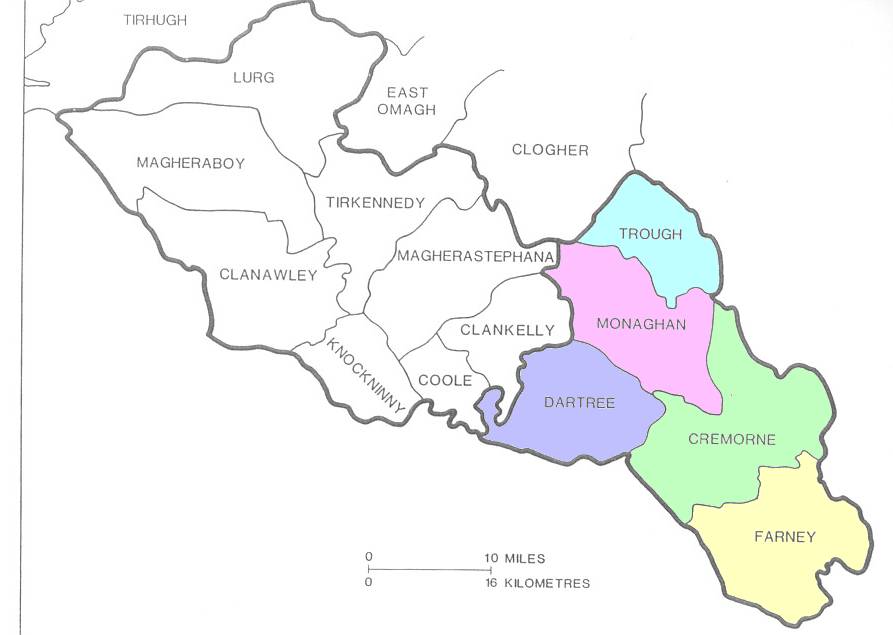
Killanny lies partly in county Louth. Inishkeen adjoins Donaghmoyne to the east. With the exception of Aghnamullen these parishes lie in the barony of Farney. The barony of Cremorne is also in county Monaghan and is immediately north of the barony of Farney. Cremorne is made up of the parishes of Aghnamullen, Ballybay, Clontibret and Muckno. With the exception of Magheracloone, the southernmost civil parish in county Monaghan, these parishes make up the baronies of Cremorne and Farney. For a map of the baronies and civil parishes of county Monaghan, go to Ann McGeough Harney's website. Below is a simplified map of the baronies, without the parish boundaries, from Landscapes of South Ulster: A Parish Atlas of the Diocese of Clogher, by Patrick J. Duffy.
An argument against the theory that Eochy MacMahon was the progenitor of the McGoughs is that his fort was in the townland of Lurgans in the parish of Magheross, but the more modern McGoughs were mostly located outside Magheross. In the page on this website entitled McGoughs, McGeoughs, and McGeoghs in County Monaghan in the 1820–30s and 1850–60s: By Barony, Parish, and Townland, the following number of names are listed in the parishes indicated:
| Civil Parish | Barony | McG[e]o[u]ghs |
| Aghnamullen | Cremorne | 84 |
| Ballybay | Cremorne | 9 |
| Clontibret | Cremorne | 27 |
| Donaghmoyne | Farney | 31 |
| Inishkeen | Farney | 13 |
| Killanny (includes part in Louth) | Farney | 33 |
| Magheracloone | Farney | 6 |
| Magheross | Farney | 1 |
| Muckno | Cremorne | 35 |
| Total for Cremorne and Farney | 239 |
In other words 239 of the 285 McGoughs in county Monaghan were in the baronies of Cremorne and Farney. Only 46 were in the baronies of Dartree (10), Monaghan (16), and Trough (20).
The fact there was only one McGough name listed in Magheross, where the MacMahon Fort at Lurgans was located, at first glance seems to be another argument against Livingstone's nomination of Eochy MacMahon as progenitor of the McGoughs. When he was dispossessed by his brother Brian in 1414, however, it is reasonable to assume that his family, the MacEochy MacMahons, moved from Lurgans to surrounding areas. Most of the McGoughs in Ireland were in these surrounding areas in the 19th century and remain there today. If you draw an arc on a map with the center point on the Monaghan-Louth boundary just south of Carrickmacross and the outer perimeter at Cookstown in county Tyrone (which is 75 kilometers, or 45 miles, due north of Carrickmacross), and bring the arc around until it touches on both the east and west a base line drawn through the starting point, you will define a space that includes the great majority of the McGoughs in Ireland. You will also have included the entire area of county Monaghan, and the part of county Louth, that was known as MacMahon country. Ignore the part of the semicircle in which lies county Fermanagh. The records show McGoughs in Monaghan, Tyrone, Armagh, Louth, and Cavan, but none in Fermanagh.
This absence of McGoughs from Fermanagh corresponds with the fact that "MacMahon Country" was pretty much limited to county Monaghan and the north part of county Louth, and did not extend into county Fermanagh. The subject is touched upon in Jim's Fermanagh Genealogy:
"The Fermanagh pedigrees belong to two groups : the dynastic kindred and its collateral branches, and the other kindreds in general, the forsloinnte as they are called in the older writings. The dynastic kindred belongs to a branch of the Airgialla named Cremthainne or Ui Cremthainn from a fifth-century ancestor. This sept held rule in two petty kingdoms, Fir Manach and Fernmag, corresponding, but not exactly, to the counties of Fermanagh and Monaghan. In the 13th century, the Monaghan line, in the family of MacMathghamhna "MacMahon (1)," held the superior authority with the title king of Oirghialla 'Oriel' ; and its pedigree, though external to Fermanagh, finds a place in this compilation." Geinealaighe Fearmanach Page 1 (Jim's Irish Family Surnames, Fermanagh Genealogy, page 1).
Considering that McGoughs are in close proximity to the fort of Eochy MacMahon at Lurgans, the small number of McGoughs in the parish of Magheross is no more than a weak argument against accepting Eochy McMahon as a progenitor of the McGoughs. As seen below, Fairtahy, the name of a townland to the immediate west of Magheross in the civil parish of Aghnamullen, means Eochy's grave. Fairtahy is close to a substantial number of McGoughs.
There are other Eochy or Eochaid MacMahons who are possible progenitors of the McGoughs. PhilipÓ Mordha, for example, suggests that Fairtahy may be the grave of the Eachaidh who was chief of the Mugdorna Breagh until about 838. See Mughdhorna under Gravestone of Eochaig of Magdarnac—or Eochaidh of Mughdhorna. The Annals of Ulster record that in the year M1273.3, Eochy MacMahon, Lord of Oriel, and many others with him, were slain by O'Hanlon and the Kinel Owen. Peadar Livingstone, in The Monaghan Story, page 47, says the first MacMahon to get the title "King of Argialla" in the annals was this Eochaidh who died in 1273.
Here is the entry on the MacMahons by Peadar Livingstone in The Monaghan Story, page 601:
"Mac Mahon (Mac Mathuna): also Mac Mathghamhna. Matthews, Ennis. The rulers of Monaghan from 1200 to 1600. In Chapters Four to Nine of this work we have described their activities as leaders. They still continued to be prominent after Kinsale and were active in the wars of the seventeenth century. They also supplied many bishops of Clogher, the most famous being Heber MacMahon who succeeded Eoghan Rua O'Neill as general of the Confederate armies in the north. Three of the MacMahon bishops later became archbishops of Armagh and Primates of all Ireland. Today, the MacMahons are the County's 4th family distributed as follows: —117N (8th), 120W (5th), 219C (2nd), and 54S."
The Celt Corpus of Electronic Texts includes an English translation of most of the Annals of the Four Masters and the original Gaelic text of parts of the Annals of the Four Masters (M), and the Gaelic texts of The Annals of Ulster (U), Annals of Tigernach (T), and the Annála Connacht (C). An experimental search interface allows a search of the more than two million words in the entire combined corpus of texts. You can search for a whole word or a part of a word. A computer search of these Annals shows many entries for Eochaidh or Eochy Mac Mathgamhna (or Mathgamha or Mathgamna), and many other examples of the surname MacMahon in both Gaelic and English.
See Searching for Irish Roots by Bryan T. McMahon, Publisher & Editor of The Ponchatoula Times.
Evelyn Philip Shirley, at page 491 of his The History of County Monaghan, says the name of the townland of Fairtahy in the parish of Aghnamullen means Eochy's Grave (feant eacaid). Fairtahy is immediately east of the townland of Lisinisky and north of the townland of Corracharra, the historic home of many McGoughs who are listed under Lisinisky Square in McGough Origins in Ireland: Random Ramblings, Rumblings, and Ruminations. Fairtahy abuts the western edge of the parish of Magheross and is less than ten miles west of the traditional fort of the Farney McMahons at Lurgans. Adjacent to Fairtahy on the east, and immediately across the border of Counties Monaghan and Magheross, is the townland of Carrickadooey. To the immediate south of Carrickadooey in county Magheross, and sharing its southwestern border with the northwestern border of the townland of Shankill in county Monaghan, is the townland of Faraghy in county Magheross. I wondered whether the aghy could have any connection with Eochy McMahon, but Shirley, at page 532, translates this name as Field of Watching (fain acaid). There may be a form of eacaid in the Gaelic name of the townland, nonetheless. The Gaelic derivation of Fairtahy contains an eacaid; of Faragh, an acaid. Could this be Field of Eochy? See the discussion in More Irish Names Derived from "Horse".
See also Mughdhorna under Gravestone of Eochaig of Magdarnac—or Eochaidh of Mughdhorna.
There is a different sept of MacMahons in county Clare who are sometimes confused with the MacMahons of Airghialla. The surname MacMahon in county Clare (or kingdom of Thomond) is said to have been derived from Mahon O'Brien, great-great-grandson of Brian Boru. The origin of the surname in Airghialla or county Monaghan is different. Old Irish-Gaelic Surnames, a supplement to Ireland's History in Maps, draws the appropriate distinction:
Mac Mathghamha - MacMahon - CO Clare - the Dal gCais, descent from Mahon O'Brien.
Mac Mathghamha - MacMahon - CO Monaghan - rulers of Oriel (Airgialla).
The Oxford Companion to Irish History (Oxford University Press 1998) contains this entry:
"MacMahon (Mac Mathghamhna) is the surname of two unrelated families of medieval chieftains, the MacMahon vassals of the O'Brien princes of Thomond or north Munster, and the MacMahon kings of Oriel (Oirghialla), approximately Co. Monaghan. In the 12th century, the Monaghan and Louth areas were ruled by the Ua Cerbaill (O'Carroll) family, whose power was extinguished by the Norman colonization of Louth. Then in the early 12th century the annals identify a new military power in the Monaghan area, as wielded by Niall MacMahon 'with his bandits'. An early genealogy traces Niall to a collateral kinsman of the O'Cerbaill kings, though the MacMahons were later to claim direct descent. Vassals of the Pipards and de Verdons in the 13th century and of the earls of Ulster in the early 14th, the MacMahons won a brief independence before becoming subordinate allies of O'Neill from the late 14th to the 16th centuries."
The origins of these two MacMahon surnames have sometimes been treated as one. The entry on MacMahon in the Irish Names section of Eolas na hEireann gets it right:
"MacMahon (or MacMahon) comes from the Irish Mac Mathghamha or, in the modern version, Mac Mathuna, from mathghamhain, meaning 'bear'. The surname arose separately in two areas, in west Clare and in Co Monaghan. In the former, the MacMahons were part of the great tribal grouping, the Dal gCais, and claim descent from Mahon O'Brien, grandson of Brian Boru. The last Chief of the Name was killed at the battle of Kinsale in 1602. The Ulster MacMahons were based in the barony of Truagh in the north of Co Monaghan, and ruled the kingdom of Oriel between the thirteenth and sixteenth centuries. Their last chief, Hugh MacMahon, was beheaded by the English in 1641. Today, although widespread throughout Ireland, MacMahon remains most common in the two ancestral homelands of Clare and Monaghan. After the defeats of the native Irish in the seventeenth century, many of the Clare MacMahons emigrated to serve in the Irish Brigade of the French Army. One of their descendants, Patrick MacMahon (1808-93), became President and Marshal of France."
The article on the surname MacMahon on the website of the Irish Times gets it wrong in that it can be read as saying that all MacMahons in Ireland derive their name from Mahon O'Brien:
"As the population grew and new families were formed, they sought to consolidate their identity by adopting hereditary surnames of their own, usually by simply adding MAC to the first name of the founding ancestor. In the course of this process, then, many surnames were created which are in fact offshoots of more common names. Thus, for example, the MacMahons ... are descended from the O'Brien family, ... from Mahon O'Brien, who died in 1129 ... The continuing division and sub-division of the most powerful Gaelic families like this is almost certainly the reason for the great proliferation of Gaelic surnames." The Origins of Irish Surnames in the Irish Ancestors section of the website of The Irish Times. [The Annals of the Four Masters for the year 1129 record: M1129.4 Mathghamhain, son of Muircheartach Ua Briain, died.]
"MacMahon Surname History by Willie O' Kane. MacMahon, one of the top five names in Monaghan, derives from mathghamhan, a bear. They are descended from Mahon OBrien, grandson of Brian Boru. [???] MacMahon was a leading sept of the kingdom of Oriel and prominent in south Ulster from the thirteenth to the sixteenth centuries. They were among the leaders of the Catholic Confederacy of the mid-seventeenth century, during which the last MacMahon chief, Hugh, and Heber MacMahon, Bishop of Clogher, were executed. In the eighteenth century three MacMahon Bishops of Clogher went on to become Primates of all Ireland; they were Hugh MacMahon, (died 1737), and his nephews Bernard, (died 1747) and Ross Rod, (died 1748)." See also McMahon Surname History by Sonia Schorman.
The O'Brien Genealogies show that Mahon O'Brien was the great-great-grandson of Brian Boroimhe—the son of Muircheartach [from whom sprang the warlike expert race, Clann Mathghamhna], son of Toirrdhealbhach, son of Tadgh, son of Brian Boroimhe:
"108 Diarmuid. A senior brother to his Diarmuid was Muircheartach ancestor of Clann Mathghamhna of Thomond according to an ollamh of the Dal gCais themselves. One of their Ollamha speaks as follows —
The children of Toirrdhealghach who shirked not fight
Were great Muircheartach and Diarmaid,
An expert progeny to whom woods bowed,
Noble Muircheartach was their senior.The children of the younger of them
Were Siol mBrian, sprung from Diarmaid;
While the warlike expert race
Clann Mathghamhna sprang from Muircheartach."107 Toirrdhealbhach, son of
"106 Tadhg. Brother to this Tadhg was Donnchadh son of Brian from whom is sprung Mac Briain O gCuanch and Clann Bhriain of Eathariach, son of
"105 Brian Boroimhe. This Brian had six sons, namely, Murchadh, Tadhg, Donnchadh, Domhnall, Conchubhar and Flann. We find only two of them to have left issue, i.e., Tadhg and Donnchadh."
For more on the pedigree of the O'Briens, see Brian, Irish Kings #175.
Jim's two Irish Surnames lists MacMahon as a Maguire Clan Associated family.
Mac Mahons, Matthews.
(page 205) "Mac Mahon Mac Mathghamhna, mod. Mac Mathúna (mathghamhan, bear). The name of two septs, both of importance. That of Thomond descends from Mahon O'Brien, grandson of Brian Ború. MacMahon is now the most numerous name in Co. Clare. In later times the majority of the many distinguished men of the name were from the Co. Monaghan, where MacMahons are numerous today, though less so than in Thomond. See Matthews. Addenda - page 304, MacMahon of Truagh was a leading sept of Oriel." [From MacLysaght's The Surnames of Ireland].
(page 440) "MacMAHONS (Mac Mathuna): While the majority of Fermanagh's MacMahons are descended from the great Monaghan MacMahons, some may be traced back to Mahon, grandson of Donn Carrach Maguire, who began a new sept of Fermanagh MacMahons. There are 108 MacMahon voters in Fermanagh today." Mac Mathghamhna, mod. Mac Mathuna (mathghamhan, bear) sometimes Matthews. [Peadar Livingstone's The Fermanagh Story]
After several years in the townland of Carrickatee in county Monaghan, Peter McGough, who was born in county Cavan, and his wife, Nancy McGurk, from the Ballybay area, bought a larger farm in the townland of Shantonagh, a short distance to the south, and moved their family there. They referred to their new farm near Bellatrain as their "Shantonagh homestead." While they farmed their fields for flax, Peter and his son James were both employed as a paymasters of a large flax and linen mill owned and operated by the Fitzherberts of Rothwell. The FitzHerberts also owned a beautiful mansion and estate in Shantonagh. The family of Peter McGough and Nancy McGurk, and especially their son James McGough and his wife, Mary Callan, are traced in McGoughs, McGeoughs, and McGeoghs in the Civil Parish of Aghnamullen under the subheading Shantonagh Rectangle.
This is an appropriate place to make a few comments about the Shantonagh estate in county Monaghan, which should not be confused with the townland of Shantonagh in Ballybay.
Peadar Livingstone, in The Monaghan Story at page 123, says that before the uprising of 1641 Colla Mac Brian MacMahon held 173 townlands in the Barony of Cremorne, which included county Monaghan. When Cromwell put down the uprising, these lands were confiscated and distributed among Cromwellian soldiers and adventurers. Later, three notable estates were formed from this land. One of these was Shantonagh which, although originally granted to Cromwellian soldiers, quickly became part of the vast Massarene possessions. James Corry obtained the Shantonagh lands from Massarene and established his seat at Tooa, Shantonagh. From the Corrys, the land descended in the female line to the Fitzherberts. Upon the Restoration, a small part of his lands was restored to Colla Mac Brian MacMahon who was then living at Tullyglass near the northeast corner of Shantonagh Lough—about a mile east of the town of Shantonagh in the direction of Carrickmacross. Most of his lands, including the Shantonagh estate, remained in the hands of the English. Livingstone says that Colla MacBrian Mac Mahon was the only Irish landowner to have any of his lands restored to him.
"The remainder of the Irish of Monaghan were now tenants. Initially, the change in status made very little difference. Had they continued to sell off their lands at the rate at which they were selling prior to 1649, little Monaghan land would have remained under Irish ownership by 1700 in any event. Nor was there any mass exodus of Irish from Monaghan after 1650. Some did leave to join continental armies and attend continental colleges but they were a tiny minority. The vast majority if people continued to live as they had been living." Livingstone, page 123.
Evelyn Philip Shirley, in The History of County Monaghan (1879) at page 254, also discusses the Shantonagh Estate:
"This was also part of Coll Mac Brian Mac Mahon's property, and after the Rebellion in possession of John Camell and John Booth, till a mortgage was satisfied for the arrears due to the soldiers of the Commonwealth, as mentioned before, was the case with a large portion of the lands in the Parish of Aghnamullen. By the Book of Distribution we find it was granted after the Restoration to Lord Massareene, under whom it is still held in fee farm rent. It has descended from Letitia, only daughter of James Corry of Shantonagh, to Thomas Fitz Herbert, formerly Rothwell, of Black Castle, in the County of Meath, Esq., who in the year 1863 took the name and arms of Fitz Herbert, representing in the female line the Fitz Herberts of Shercock, in Cavan, a younger branch of the ancient house of Fitz Herbert of Norbury, in Derbyshire,
"Shantonagh, at the time it belonged to Mr. Corry, is the scene of Miss Edgeworth's 'Black Island,' in her novel of 'Ormond,' Mr. Corry being, as it is said, the prototype of the inimitable 'King Corney.'"
Shirley publishes a "Pedigree of Rothwell, Now FitzHerbert, of Shantonagh" on page 256 of his book.
DNA testing of the Y chromosome offers hope of unraveling some of the mysteries of the origins of the McMahons and McGoughs. A project on the McMahons has been begun. See: McMahon Surname DNA Project, where results of the project to date are published. I am told that these results indicate that the McGoughs were not a sept of the McMahons, but that a recent Trinity College study indicates a possible connection of the McGoughs with Niall of the Nine Hostages, king of Ireland from 375 to 405. See my page: Genes and Genealogy—McGough Y-DNA.
| A
McGough—McMahon Connection? <http://www.magoo.com/hugh/mcmahon.html> Updated March 31, 2012 |
![[Link to www.VanGoghGallery.com]](/images/potatoesred.jpg) |
Feedback
» Site Search & Directory » © 1999–2012 Hugh McGough » |